Shut Down... Again

|
After we had scoped Webster we drove back to the Hostel and checked in to our bunkhouse. Once there, we found it mostly full of sweaty climbers in for an ice clinic associated with the ice festival. The interior was strewn with gear. We heard from a few of the guys, all students of an IMCS course, that North Conway was a complete zoo, so we drove up northwest to an Italian restaurant and plotted the next day over dinner. It was pretty simple. Get up early and get it done.
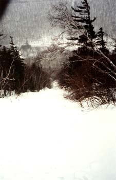
We got back to the bunkhouse, geared up for the next day, then hit the hay. The earplugs went in, the lights went out. And then it was 6am. Quick breakfast and a short weather forecast over the radio. Things did not look or sound good. It was snowing lightly when we got up and the wind was blowing steadily (what else is new?). I had paid a short visit to the main Hostel building the night before and had heard that a storm would be coming through Sunday morning. I tried to stay upbeat, and only mentioned it to Brian in passing while going to bed. "Weather not good," I'd said. "Expletive," Brian had replied. We packed our gear in the car and drove to the Willey House. And then Brian suggested we drive a little further and see whether there was a parking area a little closer to our goal, Shoestring. So we did. We drove a little further. And that's when I became very upset. You see, we're kinda stupid. We're not... from around here. See? The deal is that the day before, we'd thought, just based on location, that Landslide was Shoestring. Now, I kinda had it in my head that this might be wrong, but for some reason it seemed right. And I'd remembered very clearly being in the parking turnout at Willey's Slide and asking an experienced guide what the big route behind us was on Webster, and he'd said, "Shoestring Gully." Well, that ain't right. Shoestring is a bit further south. It's the first prominent gully you see on Webster when working south to north. And when we pulled up the road a bit, we saw it. And that's when I got upset. "Many expletives," I said to Brian. "I can't expletive believe this expletive. There's expletive Shoestring right expletive there. How could we expletive miss it?" I pulled out the guidebook and compared the lone black and white photo to the real thing right in front of us. "You're expletive right," Brian agreed. "A thousand expletives." You can't miss Shoestring when you see it. Unfortunately I was so rattled I didn't bother to take a shot so you too can visually inspect our profound fatuousness. Both Landslide and Shoestring are long, and both head up and to the left. But Shoestring's finish is unmistakable: snow on the left, rock finishes on the right. It's big. And obvious. As long as you drive up the road far enough. We briefly discuss and the snow continues to fall. We decide to drive back to the Willey House and take the bridge across the Saco River. At least that part would be easy. There are a couple ways to get to Shoestring anyhow. The way across the bridge and then up the Willey Trail and around the West Face is a way to do it. So is parking directly under the route and crossing the river and heading straight up. We were still good to go, but it was very frustrating to have thought we knew what we were doing and find out - again - that we were morons. So... we crossed the bridge with our gear and started up the trail. Sadly, the way around to Shoestring was not at all tracked. We quickly conferred and agreed to just head up the gully in front of us. We honestly had no idea what we were climbing. We just knew it was there, and that we were going up it. Kinda entertaining. The gully was a random mixture of soft, bottomless snow, breakable crust, neve, water ice, mixed ground... just about everything you could imagine. This is a shot looking back down from about halfway up the route. The going was easy enough that we soloed with no qualms. |
|
|
|